Monday 31 October 2011

Sutton Bank and Gormire Lake


A while ago I invited my mate Angela to join me on an exhausting trek up steep cliffs and across gruelling terrain.  I explained that the expedition would be arduous and only the fittest survive……. 
Not quite true, but if you see her other half, that’s what you have to tell him!
Hood Hill from Sutton Bank
In reality, Angela joined me for this walk around Sutton Bank and Gormire Lake,  (map at the end).   I was testing out my new GPS, which of course meant we went the wrong way, and Angela was testing out whether or not she should walk with me again, which of course meant we went the wrong way.

Yorkshire Gliding Club
Starting at the visitors centre we followed the Cleveland Way South along the edge of the cliff.  By 'eck it was cold up there!
We passed the Gliding Club on the left, and we watched a “tug” pull a glider into the air.  Depending on conditions and wind direction, it’s possible to watch "winch launches" of gliders straight over the edge of  the cliff.   In summer, the sky is full of silent aircraft which you watch, mesmerized, for hours.

White Horse less head

Walking on, we passed just over the top of the White Horse then turned directly right to go down the bank where out of the wind it was much warmer.  I took a picture of the White Horse at the car park on the way down, but the White Horse is designed to be seen from a distance and trying to take photo’s close up just doesn’t work.  Hence my headless version.   


Sutton Bank from Hood Hill Plantation
We walked on through the woods, so busy chatting we missed the turn off towards Hood Grange. My GPS told me we were going the wrong way, but I still haven’t worked all the buttons out, and couldn’t get the screen to tell me the right way. Luckily a woman on a horse that wasn’t headless provided directions and we were off again.

Gormire Lake


Angela, whilst fit, active and very used to climbing, abseiling, quad biking, dry stone wall building and wood clearing, is not used to walking across farmers fields.  She reminded me of the first time I went out and the finger posts pointed straight through a field of wheat or potatoes.  It felt like I was walking in someone’s back garden.  I still feel like this, and take care not to damage the farmers property.  


A tree from the Lord of the Rings on the Gormire lake side

The landowner at Hood Grange obviously knows how to look after walkers though, he’d worked his field to leave a raised unploughed path straight through the middle for us to walk on, and there is work going  to improve the right of way (I think) around the buildings. It will make it feel less like we are walking through his back garden in future.
So on, across the A170, through the fields, (where we stopped for a quick bite) and on to Gormire Lake.  


Bullrushes on Gormire Lake
Our plan was to walk along the west side of the lake and then on to Southwood Lodge, but we were talking again, and didn’t check the map, or the GPS......  Once we’d completed the full circle of the lake, (which was lovely, I like bullrushes), we turned back on ourselves and headed towards Southwood Lodge.  There are loads of paths here, and we never actually found the right one, but we did finally reach the intended route to the top of the bank.
Gormire Lake and Hood Hill from Sutton Bank


I had warned my friend that it would be steep, and that we would huff and puff all the way up.  And it was, and we did.
But it's worth it. One for the sense of achievement, and secondly the views from the top of the Whitestone Cliff are awesome.  It’s a shame the weather wasn’t a little better, but we got some great pictures of the autumn colours around Gormire Lake.


Angela on Whitestone Cliff.
The Fairies Parlour (Cave) is here somewhere


In no time at all we were back at the visitors centre, which I would recommend to anyone.  There’s educational stuff for kids and adults alike, a  little tourist gift ship, and best of all, a brilliant coffee shop with goooooorgeous cakes.  (Sorry, no beer folks).
An enjoyable day at the end of which, I’ve learnt a new walking route and how not to use my GPS.  The last question is, will Angela do it again……….?


Our intended route, around 6½ miles, although we actually walked over 7

Thursday 20 October 2011

Low Force, High Force and Holwick Scars


After a fantastic day in Swaledale on Saturday, I was expecting Sunday’s weather to be as glorious, and I was determined not to waste it.   Yvonne, (AKA Cheviot Stroller) was bulldozed into finding a route, (not strictly true, she was as keen to get out as I),  and found one of about 8 miles, starting with Low Force on the River Tees  (map at the end).  So we met up at Bowlees car park, and took the path through the tiny village towards Low Force and  Winch Bridge,
Low Force is quiet stunning.  There are four separate falls all in, and each of them quite mesmerizing. The might of all that water!  I personally loved the surrounding rockscape, created because the water is cutting through a layer of “igneous rock “ which was created by a lava flow millions of years ago.  When it cooled, the lava settled into all sorts of interesting pillars and crystalline type shapes.

We crossed the disturbingly bouncy Winch Bridge to follow the Pennine way alongside the Tees towards High Force.  

The river itself has its own rugged appeal.  The rocks and boulders are rough and craggy, refusing to be smoothed out by the flow of the river. Quite beguiling.


High Force is compelling viewing.  You just have to watch the water as it forces and gouges its way through the rock. 


I tried to capture how perilous the falls were and the awesome power of the water in photos, but the pictures are a mere shadow of the real thing.

After spending some time at High Force, we carried on up river to a charming little waterfall, Bleabeck Force.

Very pretty.


We carried on upriver.  On our right, across the Tees is Dine Holm Scar, which is also made of the cooled lava or igneous rock, and which was being quarried.  Ahead and left are the steep Green Hill and Cronkley Scars.  Lovely.
Green Hill Scar and Cronkley Scar
We turned south (ish), and away from the river at the point it turns north(ish), across some damp and squidgy grassland until we reached the wall with Fell Dike Sike on the other side.  Only a little beck, but it did require careful placement of the feet to remain dry.  Or in Yvonne’s case, walking sticks.
We walked a little further before turning east to start the way back. The damp and squidgy turned into wet and boggy.  So we were careful and picky to stop wet and soggy, (boots and feet that is).  
However, half way across this short stretch of boggy moor was Blea Beck, with its little stepping stone ford.  I have distinct memories of a very wet behind from a beck a lot shallower than this one and with  bigger stepping stones ……..
For anyone undecided about walking sticks…….. Buy them!  If only for keeping  your balance across half flooded, uneven stepping stones.  Because Yvonne is better organised than I, we were able to cross the beck using her sticks.  Of course, we wouldn’t have fallen in but the sticks gave us the confidence to cross
After that little adventure we reached the dirt track which would take us the rest of the way, through an awesome stile.

And then on through a tiny but impressive little gorge past Holwick Scar.
The very last part of the walk turns north through fields and back to the Winch Bridge, Low Force and our cars.
The weather hadn’t been quite as bright as it had the previous day, but it was another wonderful day in pleasant company.  
Lurrrrvly

Tuesday 18 October 2011

Swaledale and Swinner Gill in the October sun


Start of the walk, Black Hill on the right, Kisdon on the left


Saturday 15th October was a fantastic autumn day.  It felt like spring, and I’m sure mother nature was getting very confused.  Butterflies flitted, caterpillars crawled and flowers blossomed next to  mushrooms.  Blue blue sky and bright autumn sun.  Absolutely wonderful.


Near Ramp Holme foot bridge


Peter was exhibiting, so a few new found friends  from the Walking forum and I met up in Muker, and set off to explore Swaledale, Swinnergill and the glorious Yorkshire Moors.  As usual, the map of the route is at the end, which is better than I achieved on the walk, because then, the map stayed hidden in a drawer at home!  However, my walking friends proved much more sensible and organised than I, in that they had maps and knew the area. 


Heading towards Fair Yew End and Crackpot Hall


This blog entry also has a large number of photo’s, because it would be a sin not to show the world how lovely a day it was.


Fair Yew End


As I said, we started at Muker and made our way across the fields towards Ramps Holme footbridge.  Immediately the cameras were clicking away, it was just so fantastic to be out.
Then over the bridge, we turned left to walk alongside the Swale heading towards Crackpot Hall until we got to Fair Yew End.  

Fair Yew End ruins


Here we came to a little bridge, our first waterfalls and the ruins of an industry long since died away.  A lovely place to sit and wonder about the people who worked here and the beauty of the dales around you.


Veiw just past Crackpot Hall

From there it’s up the hill to Crackpot Hall,”the ruin of a farmhouse dating from the mid 18th century. The building may also have been used as mine offices, as intensive lead mining was carried out in the area, and there were violent disputes over mine boundaries in the 18th century. The current building was abandoned in the 1950s because of subsidence.  Crackpot Hall has been saved from further decay by Gunnerside Estate with the aid of grants from various trusts.” (Info from Wikipedia).  Our cameras are still clicking like mad trying to capture the glory of the views around us.


Steep sides of Swinner Gill


We moved on to walk along the steep side of Swinnergill under Buzzard Scar.  


Looking down into the gill


There is a higher, less risky path, but Swinner Gill looks so much better whilst perched on a 12 inch wide track. Joking aside, the little valley, waterfalls and stream looked brilliant from where we were, even if it was a little precarious.  Again, we couldn’t stop taking pictures.


East Grain beck meets Swinner Gill


Then up to the head of Swinner Gill and turn right up alongside East Grain Beck. 


Climbing up East Grain Beck


Once again, there is a higher, easier path which we chose to ignore, instead we climbed (using hands and feet) up the side of the stream with all its little waterfalls. 


Head of East Grain beck.  Moors above us


Finally we got to the top, which in a way was a shame, because it had been so nice following the stream and beck.


Looking across to Friarfold moor


But now we up on the moors, beautiful great expanses of heather and bracken.  Here, even on such a beautiful day, the wind is keen and the views are bleak. I love it.
It wasn’t long until we were on a wide dirt track skirting the moor down to Botcher Gill waterfall and along “Jingle Pot Edge”  (what a lovely name).  I’m still loving the moors views.


River Swale in October afternoon sun


The track eventually comes round to the little hamlet of Ivelet, and it’s haunted bridge?.  Here we met up with the Swale which we followed back to Ramps Holme Footbridge, and then on back across the fields to Muker itself.


Unbelievably, we had taken around 6 hours to cover just under 10 miles.  We all agreed to blame the weather. We’d spent so long enjoying the views, taking pictures and delighting in the sun, time had wandered away. Thank you to Yvonne, Rich, Donna and Frankie for making sure a wonderful day stayed perfect.  Hopefully we will do it again sometime.
Circular walk from Muker around Black Hill

Tuesday 11 October 2011

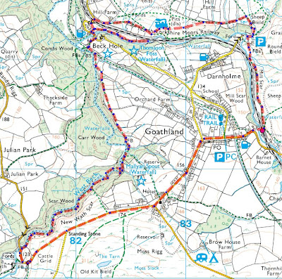
Goathland or “How to pack a lot into a short walk”.


West Beck

The Goathland Waterfalls Walk is on the Walking Englishman's site, and after watching a couple of the video’s, Peter said we should go see.  I thought “it’s a long drive for a 6 mile walk…?”  Peter wanted to go, so off we went.
If comparing, please note - Mike B started at the Mallyan Spout Hotel,  (we should've done that too), we started past the cattle grid at the bridge over West Beck.  Mike went clockwise around the route.  We went anti-clockwise.  
West Beck
So we started at the bridge, and immediately the walk became wonderful.  West Beck is a fantastic rugged little stream.  We walked alongside until Mallyan Spout and loved every minute of it.
It’s not easy.  We spent a lot of time finding footing where we wouldn’t slip off a rock or sink deep into mud.  As well as a fair amount of clambering around some of the bigger stones.  But West Beck is enchanting.  Bubbling and chuckling around the moss covered rocks. Rushing and gushing over this bit, slowing and widening into smooth, pools at that bit.  I couldn’t stop taking photographs.

Mallyan Spout
Then we came to Mallyan Spout.  How lovely is that little waterfall?  As delightful as the beck I think.  Peter has managed to capture it on film, so much better than my photographs.  I will link his video into this blog as soon as it’s ready.
From Mallyan spout there is a little climb up steps, a walk alongside the wood and steps down again heading for Beck Hole.  A big thank you to all volunteers who repair and remake  paths, such as the guys working there that day.  
We really appreciate it.


Peter says Beck Hole always reminds him of Postman Pat.  I can sort of see why.  No chance of making a phone call from the telephone booth though, it’s permanently engaged.


Steam Engine from trackside


From Beck Hole we were supposed to make our way west and very briefly alongside the railway track. Peter mentioned that we might be lucky enough to see one of the steam trains. To increase our chances we decided to take a short break and eat, and guess what?   We heard it coming and, once again, Peter has some awesome video. Wonderful.
  
Now onwards and westward. At this point:
We’ve worked out that we have to walk for a short period alongside the railway track.
Mike B, in one of his videos talks about a “scary path” which we knew was here somewhere.  Mike was walking in the opposite direction.
Peter had it in mind that we should see Thomoson Foss, which was very close by.
 All these things came together at the fork in the path yards away from where we saw the train.

Eller Beck
 The “path” on the left side was really poor, in fact there was a large hole directly in front of us, it didn’t look passable, and we weren’t even sure it was a path. The path on the right went down towards the river, and therefore the waterfall. So we went right. 
We followed Eller Beck which is almost as charming as West Beck.  Again we had to avoid mud and slippery rocks, but we were joined by a heron which flew just ahead of us to the Foss until he was perched on rock to the side of the waterfall.  He stayed there some time posing for us.  I took loads of photos whilst Peter filmed.  Lovely. 

Thomason Foss
At Thomason Foss we realised we could not go onwards.  There was no way past the waterfall,  so we turned back the way we came and tried to puzzle out how to get to the other (north) side of the railway line. That left fork was obviously the “scary path”, and we decided we shouldn’t use it.  So we went back to cross at the road bridge.  From there we walked a little way along the north side of the railway until we got to the point where the track crosses a meander in Eller Beck. 
Waterfall above Thomason Foss


We had a good look around and worked out this is where Mike went under the railway to Thomason Foss. Peter and I agree that the “scary path” in Mike B’s video is now a “positively dangerous path” and would advise others to avoid it.
On the plus side though, there’s another waterfall on the north side of the railway line. We didn’t get close, although there is a path, because we had spent so long exploring we were beginning to run out of time. 

Goathland Station


We walked on following the railway line almost, to Goathland Railway Station. Lovely views of the moors until we reached the station. This time we managed to time it to see the both steam engines roll in.  Just wonderful. 


More steam engine stuff


We spent quite a while watching trains, so now we needed to hurry back to the car.  We decided to cut the last part of the walk short, and scurry along the road through Goathland.


Someone's back garden.  What a way to commute to work.


The few words I have to say about this village are:
How pretty?
I have never known another village where the houses are so far apart.
The sheep grazing all through the village are cool.
Helicopter?

We got back to the car about 5 
hours after we started out.  We walked just less than 6 miles, but what a fantastic afternoon.  I feel like we packed a massive amount in that day.  Thinking back to the start of the day - “It’s a long drive for a 6 mile walk…?”  Never!

This is a long blog entry. We packed a lot into a little six mile walk.


Peter's very excellent short video.

Our route