Saturday 21 April 2012

Boulder Walking

On the Sunday of our weekend stay in Northern Ireland, our hosts, Jenny and Bob,  took us to Bloody Bridge, just south of Newcastle.

As it's name implies, the bridge has a violent history.  Story has it that 50 prisoners were murdered there.  The original bridge still stands, but is no longer in use.  It is however, a very pretty start of a walk from the coast up the Mourne Mountains to Slieve Donard, the highest peak in Northern Ireland.  


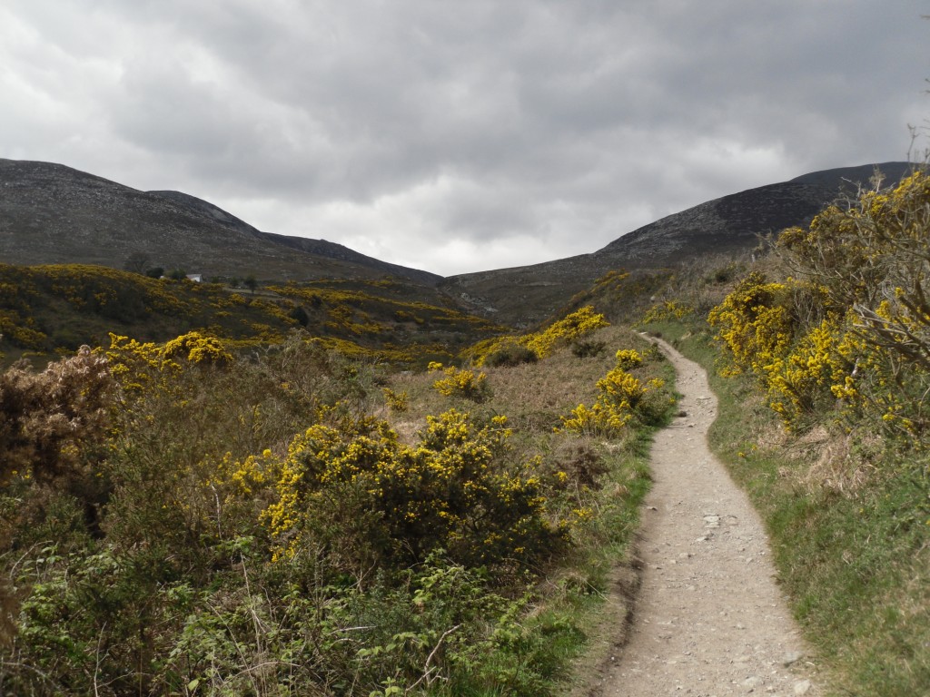
The walk starts by following the route of a stream, the name of which I haven't been able to find out.  The path keeps alongside the rocky, boulder lined beck and we started to walk, with the intention of a stroll really.


As soon as it got too strenuous, we were going to turn back as Jenny's back was playing up and she wasn't very comfortable.


But the temptation of climbing along the boulder lined bed of the stream was just to much to resist.  Within a few short minutes of starting, all four of us where clambering over the rocks.


We had a fantastic time.  For whatever reason, Jenny's back problem eased off and she was soon mucking about like the rest of us. We didn't get very far up the hill, and the earnest walkers on the paths must have wondered at the racket?  Mostly laughing and shouting, we made our way up the bed of the stream.


Bob kept choosing the most difficult routes -  vertical edges with no handholds.  We watched......  the wicked side of each of us waiting for the splash.


It never came.  A good thing really, because we would have had to turn back once he was drenched.
As I said, we didn't get too far up the hill before turning back down for a well earned cheese sarnie, but who cares.  It was brilliant fun.  
The stream and the surrounding countryside were quite beautiful and I would recommend them to anyone.  We took too many photographs to count


I think, if I were given the chance, I would love to complete the walk up to Slieve Donard, it looked stunning.  Maybe next time.....


I should point out that Jenny was unfit for work for two days after that.  Her back completely seized up from the effort!  (I'm not laughing........  Honest!)

Monday 16 April 2012

Across the Irish Sea


We visited some friends in Northern Island last weekend.  It was fantastic!  Double click on any one of the photographs to get them full screen.  (Much better).

Kinblane Castle
On Saturday, after a leisurely breakfast, we took a drive up the coast road from Belfast.

Our first stop was Kinblane Castle, a lesser known tourist attraction just a little way up the coast road from Ballycastle.
Considering the beauty of the place, it should have been overrun with visitors, but thankfully it wasn’t.  

Apparently, the castle only stood for about 8 years, and there is not much but ruins now, however, the scenery is stunning.

It reminded me of Cornwal.  

The sea was a gorgeous colour, it was a beautiful day,  we were surrounded by magnificent views and the company was excellent.

There’s a car park at the top, with quite a few steps (133 my friend counted) down, and then you get to wander around the small headland that projects out to sea.  With the weather as good as it was, and scenery like that, we couldn’t go wrong with the photographs.  Just brilliant.

Carrick-a-Rede
Carrick-a-rede means “rock in the road”.  In this case the “road” is the route the salmon take through the North Sea, between Rathlin Island and Northern Ireland. 

The “rock” is a tiny little island jutting out into that road.   Every year, between June and September, local fishermen would get across to the island to fish for the salmon.  This meant that they needed a bridge. 

The island was used for around 350 yrs, and for all that time the fishermen were building rope bridges, across the 60 ft gap.  The last one known to be in use was 89ft above the water, had a single hand rail and wooden slats that were quite a way apart.  Scary!
The one that is there now was built in 2004.  It’s still a rope bridge, bouncy and wobbly like all rope bridges, but it’s been well built and tested and is nice and safe for us touristy folk.

You have to pay to walk across the bridge and there was a little bit of a walk down to it, and then obviously back up.  We really enjoyed that.

Giant’s Causeway
We didn’t get here till about 4:30-5pm.   Apparently, if we’d arrived later, we’d have got our parking free, however, everywhere would be closed.  (Not the causeway, obviously.)

Wiki – “Some 50/60 million years ago, during the Paleogene period, Antrim was subject to intense volcanic activity, when highly fluid molten basalt intruded through chalk beds to form an extensive lava plateau. As the lava cooled rapidly, contraction occurred. Horizontal contraction fractured in a similar way to drying mud, with the cracks propagating down as the mass cooled, leaving pillarlike structures, which are also fractured horizontally into "biscuits"
Legend has it that it was built during a feud between the Irish giant Finn Mac Cool and Scottish giant Benandonner.  There are different versions of how it was built, but it ends with the Benandonner, the largest of the two crossing the causeway with the intent of fisticuffs with Finn Mac Cool.  Finn, realising that he was not big enough to win a fight against the Scottish giant, disguised himself as a baby.
When Benandonner came knocking, Finns wife told the Scotsman that Finn was out at the moment, “but here, look what a beautiful baby we have.” Benandonner thought “Cor blimey!” (in Scottish obviously) “If that’s the child, how big is the daddy?” and made a run for it, tearing up the causeway and throwing the rocks into the sea so that Finn couldn’t follow him.....

I like that story.
I suppose I didn’t really know what to expect, since I hadn’t looked it up before we went, and everything I knew was old and forgotten, so when I got there it was all sort of a complete surprise.  Peter took these very excellent pictures by the way.

First, I was surprised by how small the individual pillars were, somehow I was expecting giant stepping stones.  Secondly I was amazed at how many of them there where, and then finally, sitting up on one of the highest rocks, how small the whole area was.
A very interesting visit.  There are several structures that resemble things, such as the organ, the chimney stacks and the giant’s boot.  We didn’t get to see or photo all of them, but I enjoyed sitting on the top of the causeway,  taking it all in.    Awesome.

Guiness in an Irish pub. Our final stop of the day before driving home.  It was an excellent, excellent day and we have to give a massive thank you to our friends Jenny and Bob for making it so.  Brilliant!

Monday 9 April 2012

Brompton-on-Swale - Footpaths.


Fingrerpost for a path that leads to the A1.  Field boundaries don't have stiles or a way through.  Reaching the A1, you can't get under or over it, & to cross it would probably cause several deaths, including your own....   Confusing.


I thought I’d carry on getting to know the area around me, and drove a few miles down the road to Brompton-on-Swale to check out the footpaths there.  What I ended up doing was walking back and forth, up and down roads and paths trying to find the way through.  I got stopped by:

1. Some very expensive looking gates, (topic for discussion on The Walking Forum).
2. A couple of women walking dogs who told me “there’s no way through”.
3. And finally the A1!  (Photo above)

Each time I backtracked and tried another route.   I eventually ended up at a point where I’d walked about 5 miles and not actually got anywhere.  Feeling a bit fed up, I changed my planned route and just aimed for the nearest water. (I like water).

But it got better from that point onwards.  The map at the bottom shows the route that I was able to take unhindered.  The path along the old railway line north of Brompton is really quite nice, 
As is the one that goes alongside the A1 at Brompton until the point you can cross under it. (Not a public footpath, but a local one).  this photograph is of a flower called Honesty.  It really is very pretty.
I didn’t think Howe Hill Lane was that interesting, as trees are planted to block sight of the gravel pit lakes on either side, but the walk alongside the Swale was very pleasant.   Bolton on Swale Lake looked fantastic, what I could see of it from the track.  I think I will go back once I’ve worked out how to get closer to the water’s edge.  The river photographs are all of stretches I'd not seen before.

From the lake, I returned the way I came until Catterick Bridge, the photo is the old railway bridge very close by. You can just see Catterick Bridge behind it. 
From there I continued to follow the Swale back along to where my car was parked.  I met a farmer who told me that the there was a new footpath that followed river bank all the way round now (not as shown on my map where i crossed the fields).  Yippee. 

I ended up walking nearly 10 miles all in and learnt about a few more paths in Yorkshire.

Sunday 1 April 2012

Back to the Batts

It was a lovely afternoon and with nothing better to do, I took a walk down to Colburn Batts.
Walking along the old railway line from "The Station" in Richmond you can see through the trees on your left over to St Agatha's House and Easby Abbey.  Doesn't it look so typical of English countryside?
Turning right off the railway line to follow the coast to coast you walk through Iron Banks wood.  Today it was carpeted in wood anemone's, with a sprinkling of primroses and bluebells.  Lovely.
Following the river until you get to the Batts.
I spent an hour at The Batts watching the goings on.  This pair of greylags were best of friends with the canada geese.  As a foursome they seemed to go everywhere together.
And this gentleman was absolutely full of temper and testosterone.  He hissed at everything in his vicinity, including me. He preened and flounced and was full of bravado and display the whole time I was there.  His lady friend was having a nap and didn't take a lot of notice. (She did wake up eventually).
I'm dead pleased with this picture.  Somehow I managed to get a nearly clear photograph of the great crested grebe with my little compact.  I've seen two pairs and a lonesome one today.
Today's count was one pair of goosanders, one heron, I don't know how many swans, tufted ducks and coots, about a hundred black headed gullss, one pair of canada geese and quite a few greylag geese.  And of course the great crested grebes.   
This guy (or mebbe its a gal?), was making quite a lot of noise as I went by the farm at Colburn Hall on the way home.  Handsome animal tho'. I also managed to see a pair of male goosanders swimming upriver on my way back.  That sort of surprised me. I don't know if there are more of the birds on the river this year, or if I've just not seen them before
And finally, although I don't know what type of tree this is, I thought these were quite lovely.

6 1/2 miles in the sunshine and my left foot is just about fully recovered.  Wonderful.