Monday 28 November 2011

Whernside


Whernside from Bleamoor Sidings
Force Gill Aqueduct


Force Gill Aqueduct.  Ingleborough in the distance
It wasn’t supposed to be cold, wet and windy.  The forecast was for sun and a bit of a breeze. As we drove from Richmond, through Redmire and Hawes, the weather was lovely.  But as we left Hawes and approached the Ribblehead Viaduct, the weather turned.  The blue sky went black, the sun hid, the wind made the car feel like it had dropped a gear and the rain hammered the windowscreen.  All I could think was “That’s mean!” 


We parked near the viaduct and went to the back of the car to get our boots.  OH MY GOD!  (Except I’m not religious.) How cold was that wind?  The extra clothes we didn't need but dropped into the boot anyway,  were suddenly very, very necessary.  I ended up in 5 layers and 3 hats.  Waterproof trousers and ski gloves were donned.  It was so cold. 

Nameless tarn on the slopes of Whernside

A view from ridge up to Whernside Trig Point


The Ribblehead Viaduct from Whernside
Ribblehead Viaduct from Bruntscar
Darkness Descending on Ribblehead Viaduct
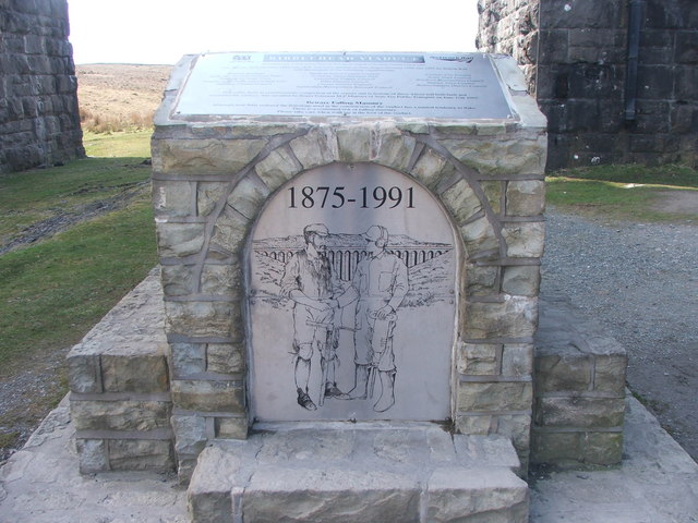
Commemorative plaque, from the Geograph Website.
 © Copyright Steve Partridge and licensed for
 
reuse under this Creative Commons Licence.  
Once dressed for the weather we started walking.  The rain came at us sideways - ice needles against the face.  After 100 yards I looked at Peter and asked.  “Are we really gonna do this?”  “Yep,” he sez “we’re here now”.   So, head down, off we went.


Now I have to be honest, I was looking forward to this walk.  Not because going up Whernside would mean I’d completed all three peaks, but because of the Ribblehead Viaduct.  I have always been fascinated by it, and wanted to get up close.  So now, here we were, walking alongside it, but the weather was so bad I couldn’t lift my head to look.  Very disappointing.  Peter pointed out that we would pass it on the way back, but remembered it would be dark.  I was quite disheartened.


Then, as suddenly as it started, the wind and rain stopped and the sun appeared.  It was just lovely.  We weren’t far into the walk, only at Blea Moor station house, and now we could get the cameras out. Unzipping coats and removing gloves, the walk became a pleasant experience.


From the station house, we went on to the Aqueduct, which I wanted to see and found interesting, and then the start of the climb to the top of Whernside.  Lots of lovely things to see, such as Force Gill waterfall, in full flow due to all the recent rain, a tarn with no name and the fantastic views from the walk along the top.


And as for the weather? It was like a teenage girl getting ready for her first date.  It couldn’t settle on anything.  The sun came out, and then disappeared.  The sky was clear, then full of black clouds.  The rain disappeared over the horizon and then came back suddenly, all cold and hard.  


And the wind.........?  Well the wind was usually trying to blow us over, and almost succeeding sometimes.  But then, just to be contrary, it disappeared entirely?  Trying to walk up hill with the wind against you makes an easy slope hard work.  Taking our gloves off meant that our hands started to feel frozen within minutes.   Every so often you felt a gust nearly knock you over.  It was exhilarating.  And cold!
So we got to the top of Whernside, ate a cold Cornish pasty with gloved hands, enjoyed the glorious views and then made the descent.  We knew we would have to get a move on, because it would be dark by four o’clock.  


We kept getting closer and closer to the viaduct, and I kept taking more pictures.  Finally we were there, and it wasn’t raining, or blowing a gale and I could have a good, but hurried look, because it was really getting dark.  An amazing piece of architecture I reckon, and I especially like the commemorative plaque beneath.  Eloquent.   
Our route
Despite the weather, it was a good walk and an interesting day.  I think I might like to do that one again sometime.  But perhaps in better weather 

Sunday 13 November 2011

Roseberry Topping. On the edge of the Moors.

Roseberry Topping from the South

Capt Cook's monument on Easby Moor

Under bright blue skies and glorious sunshine we set of for Great Ayton to start a lovely afternoon 7 mile walk.  We parked in the little town and once booted up, and with GPS switched on (still learning), off we went. The weather was absolutely wonderful for November; we were soon warm enough to strip down to T-shirts.  Leaving Great Ayton and heading for Roseberry Topping, the fields were beautifully green in the sun.  We could see the Cook Monument up on Easby Moor to our right, and were lucky enough to catch sight of a couple of deer in a field to our left.
Woods in the November sun 


Then, across the railway line and up the hill through the lovely little Cliff Ridge wood. The trees and autumn leaves were quite wonderful.
The walk up to Roseberry Topping
Next we walked along the top of the hill towards Roseberry Topping.  Info from Wikipedia.  As we approached we saw an interesting little folly, which seemed to make most visitors stop and wonder about it.  I checked it out when we got back, and according to the Wiki it is actually an old hunting lodge.  


Then it was up Roseberry Topping, with its distinctive shape.  It’s not overly high and obviously the place to visit on a sunny day in November.  There were loads of people there, families and groups, large and small.  The wind was visiting too, sharp and cold.
View north east from Roseberry Topping


We didn’t stop for long, too many people about.  The edge of that cliff is scary but the views around you are extensive.  You’ve got the sea to the north east, the moors east and south, flatness to the west and the industry and urban terrain of Middlesborough to the North.
From there we went west heading for Newton Moor then south to walk down the on the edge of Slacks Wood.  On our left glorious, extensive, bleak heather moorland complete with noisy grouse.
James Cook Monument


On our right the pine trees and decimation of a commercial wood. We came across a group or riders out on a hunt.  There weren’t any hounds, so I am not sure what they were “hunting”.  Horses and riders looking all spruce and brushed up was very lovely to see.
As the sky started to cloud over we moved on and aimed for our next point to visit,  Captain Cook’s monument.  It turns out that the man who discovered Australia used to climb Roseberry Topping to get away from it all. Wikipedia James Cook Early Life
Now which way? 


The last part of the walk was to follow the path in a big zig zag down the bank to Easby Wood.  Not successful, because near the wood, the way through the bracken just disappeared……We'd seen little yellow way marks...... but the path just stopped?  At this point, because we knew it was going to get dark soon, we opted to change our route and follow the tracks and roads back to the car.  So we headed directly for Southbrook Farm and from there took the lane back to Great Ayton, arriving just as the sun disappeared.


A really lovely afternoon walk, made so much better by the beautiful blue sky and warm sunshine. Now I can finally say I’ve been to Roseberry Topping.

Tuesday 1 November 2011

A walk in the North Pennine moorland from Stanhope


View from Wolsingham Park Moor
Shittlehope Burn and what looks like a sort of tunnel.

This was a test walk.  Neither I nor Yvonne (Cheviot Stroller) had been out this way before.  So I sort of cobbled together a route of what looked like interesting features and met Yvonne in the little town of Stanhope.  We parked at the Durham Dales Centre and quickly set off, aiming for the cave(s) on the wonderfully named Shittlehope Burn.  (Map at end as usual)


Looking down on Ravensfield
I was slightly disappointed in that we couldn’t really see any caves, just a hint of rocks where they might be.  There looked to be an interesting tunnel though, but because everywhere was wet, muddy and slippery we decided not to explore.
From there we muddled our way across the fields to the tumbledown farmhouse which would have been Ravensfield, and then up the steep side of Shittlehope Edge.  
Roundhill Quarry


The paths here are not marked or very clear, and it was basically guesswork that got us to the Pit House.  We did unintentionally visit Roundhill Quarry on the way, which had its own charm.


The Pit House and Pit Mine


We got to the Pit House from where we were supposed to follow the right of way south, down the hill and then come back up again on Intake Lane.  We decided to try and take a short cut straight across to the tantalisingly close satellite mast.  This meant walking across the disused mine workings, (curious ups, downs and gulleys in the field), and over a damaged stone wall to rejoin our path, but it did save us another uphill climb, (shortcut not recommended).

From the satellite mast, we walked north on a clearly defined and waterlogged track on the edge of Wolsingham Park Moor.  The moor is bleak with nothing but heather for miles, as well as loads of very noisy grouse. Apparently the gentry don’t shoot on Sundays, which is probably why we didn't see another soul up there.  Despite overcast skies, the views were fantastic and we could see right across Weardale to the west and to the wind farm on the other side of Tow Law to the east.  Awesome.
More views across the moors
We passed Fatherley Hill, which is charming, and the mast at Collier Law to reach The Sandpit.  An odd place.  Obviously a disused sandstone quarry, it has its own alien landscape.
From there we headed for Weatherhill Engine, an old railway station described here:  Disused Stations Stanhope,  but any evidence of it is long since gone.  We crossed the road here, and found the finger post pointing to the public footpath that would take us down the bank to a gully and then on to the disused drift mine.  Finger post…… Yes. Path…..  No.  So we headed in the right general direction across the heather until we met up with our next path.
Disused Drift Mine


Then it was down to the disused drift mine, which I think might have closed in 2002.  The buildings are relatively modern.  I liked it here, shades of Jurassic Park 3, and surrounded by autumn trees.  Lurrrrvvly.


Reahope Burn


Onwards to meet up with Reahope Burn.  We followed it until Stanhope Burn which we walked alongside until we got to Stanhope. The sun was out in full force now, showing up the glorious colours of the woods we were walking through. This was a really delightful stretch of the walk, thoroughly enjoyed by us both in the low afternoon sun.
The woods next to Stanhope Burn


Then we were back in Stanhope and at our cars.  We’d walked just under 10 miles and explored an area new to us both.  Definitely some highlights on the walk, not least the views and the bleakness on the edge of Wolsingham Park Moor, as well as walking along the burns back into Stanhope.  Wonderful.  Thank you to Yvonne for keeping me company and steering both me and my GPS right as we walked round.


Our planned route of 10.2 miles. Except we didn't follow it entirely.